
This article has been republished with permission from the Niagara Peninsula Aspiring Geopark website. Read the original article here.
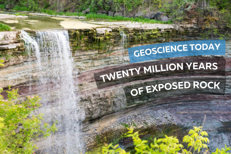
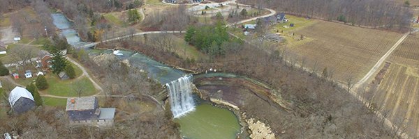
The Balls Falls Conservation Area, located prominently on the edge of the Niagara Escarpment, beautifully exposes a succession of Upper Ordovician and Lower Silurian rocks along a length of over 2.5km and a vertical dimension of about 65m. This excellent exposure is the result of river and slope erosion dominated by the northward flow of Twenty Mile Creek, over the Upper and Lower Falls, and ultimately into Lake Ontario.
Paleozoic Geology
Aside from the Niagara Gorge, Balls Falls is one of the few locations in the Geopark where bedrock formations are so well exposed to reveal the geologic history of the region. As shown on this geologic cross section, rock seen along the length of the valley spans a time of roughly 20 million years from the Upper Ordovician Queenston Shale to the Lower Silurian Lockport Formation Limestone.
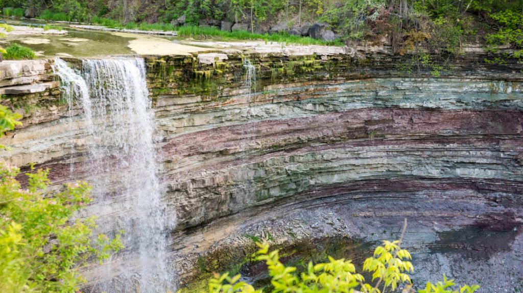
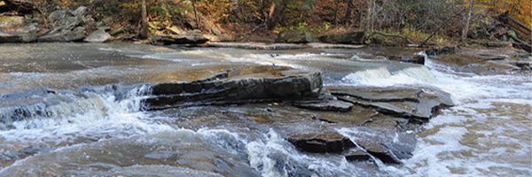
Many of the rock layers can be seen at the Lower Falls located next to the grist mill. It is astounding to realize that from this single vantage point, one can witness so much of the earth’s history. The oldest visible rock formation, the Power Glen Shale (438 my), lies at the base of the falls and the youngest, Reynales Formation Limestone and Shale, is seen at the top.
Formations both younger and older are exposed along the valley. Overlying Rochester Shale and Lockport Dolostone form the structure of the Upper Falls while older rocks are exposed below the Lower Falls – buff coloured Whirlpool Sandstone is seen within the gorge walls and river bed and the Queenston Shale Formation, the oldest rock exposed in the Geopark, outcrops further downstream in the prominent cliff just north of King St.
The Waterfalls
The Upper and Lower Falls are located at two different levels in the stratigraphy. These two levels were created by a combination of scouring glacial action, ending as the last glacier retreated about 12,000 years ago, and by the erosive power of flowing water – most significantly as torrential glacial melt runoff at various periods in history, and later in a more subdued manner as drainage along Twenty Mile Creek.

Upper Falls, Ball’s Fall’s Conservation Area 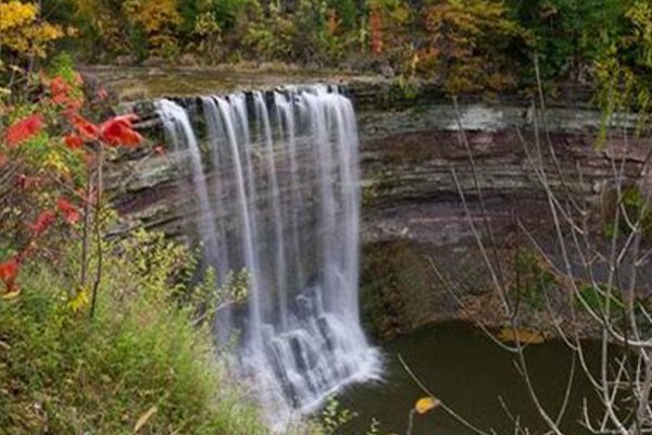
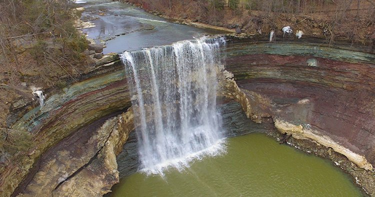
Lower Falls, Ball’s Falls Conservation Area
The Upper Falls at 11m high is classified as a curtain falls since the width is greater than its height. About 1.5km downstream, the main Lower Falls at 27m high is considered a classical falls because the height and width are almost equal. Further downstream there is a collapsed waterfall that formed over the course of the past 10,000 to 12,000 years, as the rock layers receded due to erosion.
The Gorges
The erosional history of the Gorges at Ball’s Falls is complex. Today, you see two active gorges – one below each of the two waterfalls. They have been excavated by two, and possibly more periods of erosion, separated by phases in which the entire area was covered by glacial ice. When the ice last retreated (which was at its peak was at least 1km thick) it left the area covered with glacial till, clay and silt thereby plugging these previously excavated sections of the gorge. As the glacier retreated and water flowed again in the gorge, the weak and loosely consolidated glacial remains were washed out and the “buried gorge” was revealed again.
There are also two abandoned gorges – one on the west side of each of the two waterfalls. These abandoned gorges were active over 25,000 years ago.
The Valley Slopes
Weathering on the steep slopes of the gorges gives rise to two main types of slope movement: individual rock falls and rock slides.

Individual rock falls take place unnoticed most of the time and is very common on open exposed cliff faces. Large rockslides take place less often – once every six to ten years – but produce a much more obvious result. In 1981, a slide on the east side of the valley occurred as rock at the top of the slope failed, slid down the slope towards the gorge floor and forced the closure of the road. This occurrence was an excellent example of how the gorge evolves – the gorge enlarges and rock is delivered to the river channel to be gradually eroded and carried downstream.
The River and Water Flow
Twenty Mile Creek is named for the location of its mouth, twenty miles (32 km) west of the Niagara River along the Lake Ontario shoreline. The Indigenous name for the Twenty Mile Creek is the Kenachdaw, which translates to Lead River. It is 50 km in length and drains an area of roughly 290 sq km.
River flow in the river normally dries up in the late summer and early fall, although there can be considerable variation in the timing. The largest flood events are usually between January and April as rainfall and melting show pack on saturated ground with little vegetation cover often combine to produce dramatic floods.
At the Upper Falls, water flows underground and re-emerges at the cliff on the east side of the falls.

Contributor: Niagara Peninsula Conservation Authority
Author (photo on left): Perry Hartwick, P.Geo, Niagara Peninsula Aspiring Global Geopark Director and Resident Geologist, Co-founder and President of Upper Canada Stone Company, Ltd., which successfully operates a dozen quarries in Ontario under the Aggregate Resources Act.